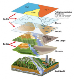

What is GIS?
A Geographic Information System (GIS) intergrates hardware, software, and data for capturing, managing, analyzing, and displaying all forms of geographically referenced information. GIS allows us to view, understand, question, interpret, and visualize data in many ways that reveal relationships, patterns, and trends. GIS helps you answer questions and solve problems by looking at your data in a way that is quickly understood and easily shared in the form of a map.
GIS in the City of Newberg
The GIS at the City of Newberg started in 1996 when groundwork for the computerized mapping system was implemented. The GIS has been developed and continues to be developed through cooperative efforts of GIS Staff, other City Staff, and Yamhill County.
City of Newberg's GIS Retrieves Information ASAP! After facing several years of remarkable growth and expansion, Newberg expanded its GIS program to accomodate these changes. Now the City can access scanned images of the City's as-built drawings, subdivision plats, and other information more easily using GIS.
Suggestions for maps or map content that you would like to see on the City of Newberg website are always welcome.